

Rising Alpine Temperatures Drive Unpredictable Debris Flows in Swiss Alps, Experts Warn
As climate change accelerates permafrost thaw and alters rainfall patterns, Alpine debris flows are growing faster and more intense, according to research from the University of Geneva.
By The Global Wire Newsroom · Reported from Simon Bradley
Link preview · horizonglobalnews.com
Rising Alpine Temperatures Drive Unpredictable Debris Flows in Swiss Alps, Experts Warn
As climate change accelerates permafrost thaw and alters rainfall patterns, Alpine debris flows are growing faster and more intense, according to research from the University of Geneva.
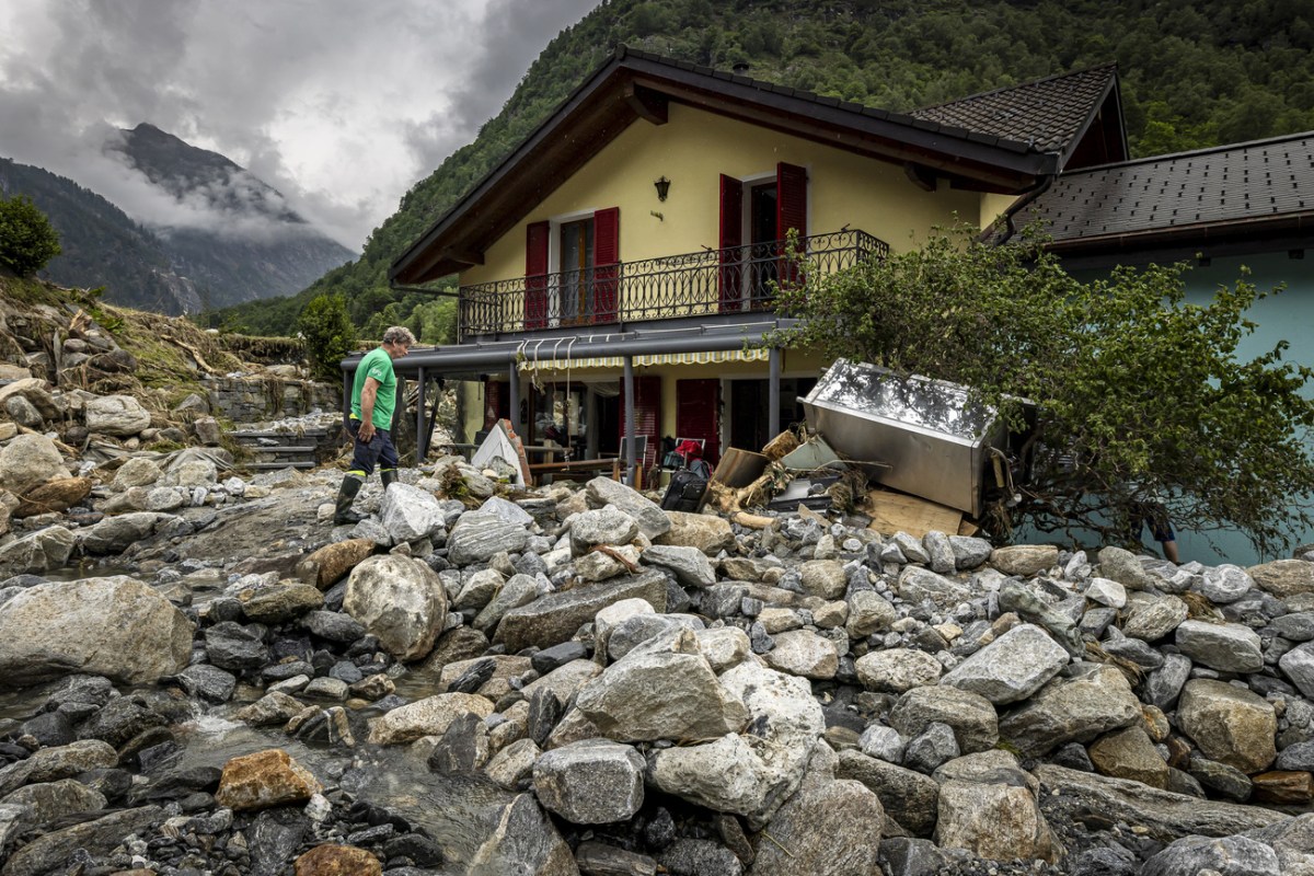
Alpine debris flows are becoming faster, larger, and increasingly unpredictable as the climate crisis alters high-altitude environments across Switzerland and the broader European mountain arc. In an assessment reported by Swissinfo, climate scientist Markus Stoffel, who heads the newly established Chair of Mountain Hazard Research at the University of Geneva, warned that traditional models used to anticipate mountain hazards are being rendered obsolete by accelerating environmental changes. Higher global temperatures are thawing permafrost that previously stabilized steep mountain slopes, while changing atmospheric conditions are delivering intense, concentrated rainfall events into high-altitude catchments. Together, these forces are mobilizing vast quantities of loose sediment, mud, and rock, heightening risks for settlements, transport corridors, and critical infrastructure located in mountain valleys below.
Key facts
What happened
In an interview with Swissinfo, Markus Stoffel detailed how the physical mechanics governing Alpine debris flows are undergoing a fundamental transformation due to ongoing climate change. Debris flows—saturated surges of soil, rock, and water that move rapidly through steep gullies—have long been a structural feature of Alpine geomorphology. However, Stoffel highlighted that the environmental triggers generating these torrents are shifting in ways that make them significantly more destructive and challenging to forecast.
At the core of this transformation is the thaw of Alpine permafrost. In high-altitude terrain, permanently frozen ground acts as a structural adhesive, binding together fractured rock walls, scree fields, and loose glacial deposits. As mean annual temperatures rise, the active layer of permafrost—the uppermost section that thaws during the summer months—is deepening, while deeper subterranean ground temperatures continue to climb. This thermal degradation liberates vast volumes of unstable rock and sediment into upper drainage basins.
Simultaneously, changing atmospheric conditions across Western Europe are altering precipitation profiles over high mountain ranges. Rather than prolonged, moderate rainfall, climate warming is intensifying short-duration, high-intensity storm activity over high-elevation catchments. When heavy downpours fall onto high basins laden with freshly thawed sediment, the material quickly becomes supersaturated. Once a critical moisture threshold is breached, the mass liquefies and surges downhill, picking up speed, heavy boulders, and uprooted vegetation as it cascades toward valley floors.
Stoffel noted that these compound factors severely diminish the reliability of historical risk-assessment models. Standard hazard mapping and engineering design parameters have traditionally relied on statistical return periods—such as 50-year or 100-year flood and landslide events—derived from historical meteorological and geological records. Because baseline climate conditions have shifted permanently, historical records no longer accurately reflect the actual frequency, speed, or volume of contemporary debris flows.
Why it matters
The shifting dynamics of Alpine debris flows present major operational challenges for emergency responders, municipal planners, infrastructure operators, and valley residents across Switzerland and neighboring Alpine nations. In a nation where narrow valley floors concentrate dense residential communities, rail networks, power grids, and international transit corridors, uncontrolled mass movements pose systemic risks.
Transportation infrastructure is particularly exposed. High-capacity transit routes, including national motorways, regional rail corridors operated by Swiss Federal Railways (SBB), and major mountain pass roads, routinely cross active hazard zones. A severe debris flow can bury road sections or damage railway tracks, severing critical freight and passenger links for days or weeks. Energy facilities, including high-voltage distribution lines and hydroelectric stations embedded in steep catchments, face direct physical threats from high-velocity rock and sediment impacts.
For municipal governments, the evolving hazard profile carries heavy financial and legal ramifications. Cantonal regulations mandate that local authorities maintain up-to-date hazard maps (Gefahrenkarten) that govern municipal building codes and land-use rights. As debris flows reach larger volumes and extend into areas previously classified as low-risk or safe, local councils face difficult decisions regarding building bans, property devaluation, or mandatory structural retrofitting.
Additionally, physical defense infrastructure—such as heavy concrete retention basins, channelization dams, and automated sensor networks—requires substantial public investment. Upgrading and maintaining protective structures to withstand larger, more frequent debris flows will place growing budgetary pressure on federal, cantonal, and local taxpayers.
The background
Understanding the heightened threat of Alpine debris flows requires examining the broader environmental and institutional framework of Swiss natural hazard management. The European Alps serve as a highly sensitive climate indicator, experiencing surface warming at nearly double the global average. Since the pre-industrial era, Switzerland's national mean temperature has risen by more than 2 degrees Celsius, leading to rapid glacier retreat and widespread ground warming in high-elevation areas.
Permafrost is present beneath approximately 5% of Switzerland's total land area, typically at elevations above 2,500 meters. For millennia, this frozen ground preserved structural stability across steep mountain faces. As prolonged heatwaves become more frequent, ice cohesion within rock fractures degrades, driving an increase in rockfalls and slope instability.
A prominent example occurred in August 2017 in the Bondasca Valley in Canton Graubünden. A massive rockfall of over 3 million cubic meters detached from Piz Cengalo, striking a glacier below and triggering catastrophic debris flows that swept down to the village of Bondo. The event resulted in eight deaths, forced the temporary evacuation of the village, and caused tens of millions of francs in damage to public and private property. Subsequent smaller events across the Valais and Bernese Alps have reinforced the reality that high-altitude rock instability directly threatens low-altitude communities.
Switzerland manages these threats through a coordinated institutional framework led by the Federal Office for the Environment (FOEN), which establishes national strategy and funds protective works. Scientific support is provided by specialized bodies, including the WSL Institute for Snow and Avalanche Research (SLF). The creation of the Chair of Mountain Hazard Research at the University of Geneva represents an initiative to advance scientific understanding of compound natural hazards and to refine practical risk-reduction tools for local decision-makers.
Reaction
The concerns raised by Stoffel reflect an emerging consensus among geoscientists, civil engineers, and hazard specialists across the Alpine region. Municipal authorities and cantonal natural hazard departments in high-exposure areas such as Valais, Graubünden, and Bern are actively seeking upgraded monitoring and forecasting tools to adapt to changing environmental conditions.
Cantonal hazard specialists have increasingly recognized that relying solely on physical containment structures is no longer sufficient against extreme, high-volume flow events. Consequently, there is growing emphasis on expanding automated monitoring systems, including early-warning Doppler radar, ground-based radar, and real-time acoustic sensors connected to automatic traffic barriers.
Environmental organizations and climate researchers point to rising Alpine instability as a direct consequence of global greenhouse gas emissions, advocating for stronger mitigation policies alongside regional adaptation investments. Meanwhile, local business associations and tourism agencies in mountain valleys are calling for balanced hazard management strategies that maintain public safety without unnecessarily restricting access to high-altitude transit routes, ski resorts, and hiking corridors.
What we don't know yet
Despite advances in Alpine geomorphology and climate modeling, major uncertainties remain regarding the precise timing and scale of future debris flows. A primary open question involves the exact local precipitation thresholds required to trigger a debris flow in a specific catchment. Because mountain weather is highly variable, localized torrential rain cells often evade standard meteorological radar networks, making short-term early warnings difficult to issue with high precision.
Furthermore, scientific data regarding the internal thermal structure and ice content of many remote permafrost sites across the Alps remains limited. While satellite monitoring provides top-level surface displacement measurements, mapping subsurface ice-to-water ratios deep within specific rock walls requires direct borehole drilling, which is logistically complex and expensive at high altitudes.
There is also uncertainty surrounding the long-term durability of existing physical protective works when subjected to compound events—such as multiple, sequential debris flows occurring within hours or days before maintenance crews can clear accumulated sediment from retention basins.
What to watch
Key indicators in the coming months and years will show how effectively Swiss authorities and research institutions adapt to evolving mountain risks. A major milestone will be the initial research findings and predictive risk-modeling tools published by the University of Geneva's new Chair of Mountain Hazard Research under Markus Stoffel.
At the institutional level, observers should monitor updates to federal hazard mapping guidelines issued by the Federal Office for the Environment. These updates will dictate how cantonal authorities formally incorporate future climate projections into territorial planning and building regulations.
Additionally, watch for the field deployment of next-generation early-warning technologies, including satellite-based interferometric synthetic aperture radar (InSAR) and automated catchment sensors. The operational performance of these systems during upcoming summer storm seasons will serve as a key test of whether real-time data can effectively mitigate risks to human life and vital transport routes across vulnerable Alpine corridors.
This article includes original news reporting conducted by journalist Simon Bradley and originally published by Swissinfo.
How this story was produced
This report was written by The Global Wire newsroom from reporting first published by Simon Bradley. We verify the core facts against the original report, write our own account, and add the background and consequences a short wire item leaves out. Drafting is AI-assisted inside an editor-supervised pipeline, and every story is checked for accuracy of attribution, structure and duplication before it appears — full detail in our AI and funding disclosure.
Spotted an error? Tell us at corrections@horizonglobalnews.com and read our corrections policy or editorial standards.
Reader comments
Loading comments…