

Robotic Submersibles Map Vast Deep-Sea Lava Fields Off Oregon Coast
Scientists using high-resolution underwater robotics discover expansive volcanic terrain more than two kilometers beneath the Pacific Ocean.
By The Global Wire Newsroom · Reported from TOI Science Desk
Link preview · horizonglobalnews.com
Robotic Submersibles Map Vast Deep-Sea Lava Fields Off Oregon Coast
Scientists using high-resolution underwater robotics discover expansive volcanic terrain more than two kilometers beneath the Pacific Ocean.
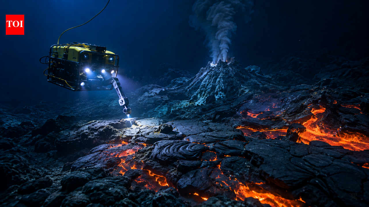
Marine scientists utilizing advanced robotic submersibles have uncovered expansive, previously uncharted lava fields surrounding an active underwater volcano more than two kilometers beneath the surface of the Pacific Ocean off the coast of Oregon. According to reporting by TOI Science Desk, researchers from the Monterey Bay Aquarium Research Institute deployed high-precision robotic vehicles capable of withstanding the crushing hydrostatic pressure of the deep sea to conduct detailed surveys of the abyssal terrain. The discovery reveals a dramatic submarine landscape formed by dynamic volcanic activity, providing unprecedented visual and spatial data on how magma flows behave under the extreme physical conditions of the deep ocean floor.
Key facts
What happened
According to reporting by TOI Science Desk, the research team from the Monterey Bay Aquarium Research Institute (MBARI) targeted an active submarine volcano off the Pacific Northwest coast, deploying deep-sea robotic platforms to explore regions hidden beneath thousands of meters of water. Operating in an environment where pressures exceed 200 atmospheres—more than 200 times the atmospheric pressure at sea level—the autonomous and remotely operated submersibles executed methodical survey grids across the seafloor.
Equipped with high-frequency multibeam sonar, laser scanning systems, and high-definition cameras, the robotic platforms swept over the rugged terrain to generate meter-scale bathymetric maps. The resulting data revealed massive, sprawling fields of volcanic rock extending across regions of the seabed that had previously appeared featureless or poorly defined on low-resolution surface-ship sonar tracks.
Visual inspections conducted by the submersibles captured a diverse topography of volcanic landforms. Scientists identified extensive smooth sheet flows, which form when high-flux, high-temperature lava rapidly spreads across flat abyssal plains, alongside bulbous pillow lavas created when molten rock extrudes slowly and cools instantly upon contact with cold seawater. In several sectors, complex lobate flows and collapsed lava channels were documented, offering direct evidence of past catastrophic eruptions that reshaped the ocean floor.
Why it matters
Despite covering more than 70 percent of the planet's surface, the ocean floor remains significantly less mapped in detail than the surfaces of the Moon or Mars. Submarine volcanoes represent the primary mechanism by which Earth transfers heat and material from its mantle to its surface, with an estimated three-quarters of the globe's annual volcanic rock generation occurring beneath the waves. However, because deep-ocean eruptions occur hidden beneath kilometers of water, observing their structure and extent has historically proven extraordinarily difficult.
The high-resolution mapping of these deep-sea lava fields provides geologists with crucial empirical evidence to refine models of oceanic crust formation. Understanding the volume, spread, and cooling dynamics of underwater lava helps researchers calculate global magmatic output and assess how heat budget cycles affect ocean chemistry.
Furthermore, deep-sea lava flows are directly linked to hydrothermal vent systems. When cold seawater percolates through fractured, freshly cooled basalt and contacts underlying magma chambers, it dissolves minerals and emerges as superheated, mineral-rich vent fluid. These hydrothermal vents sustain complex, chemosynthetic biological communities that thrive entirely independent of sunlight. Mapping new lava fields allows marine biologists to trace the birth, migration, and succession of these unique deep-sea ecosystems, which rely on chemical energy rather than photosynthesis.
The background
The waters off the Oregon coast lie directly above the Juan de Fuca Plate, a small oceanic tectonic plate that is actively spreading away from the Pacific Plate at the Juan de Fuca Ridge while simultaneously subducting beneath the North American Plate to the east. This complex tectonic environment makes the Pacific Northwest offshore region one of the most volcanically active marine zones in Northern America.
Prominent features along this boundary, such as Axial Seamount and adjacent ridge segments, have been the focus of multi-decade marine geology research. Axial Seamount, located approximately 480 kilometers off the Oregon coast, experienced major, well-documented eruptive events in 1998, 2011, and 2015. During those events, oceanographic monitoring networks detected thousands of micro-earthquakes, localized seafloor deflation, and extensive fresh lava extrusions.
Historically, oceanographers mapped the seafloor using hull-mounted acoustic echo sounders aboard surface research vessels. While effective at defining broad bathymetric features like subsea mountains and trenches, surface-based sonar loses spatial resolution as sound waves disperse through thousands of meters of water, yielding grids with resolutions of tens or hundreds of meters per pixel.
Over the past two decades, institutions like MBARI have pioneered the use of Autonomous Underwater Vehicles (AUVs) and Remotely Operated Vehicles (ROVs) operating just meters above the seabed. By placing high-frequency sonar sensors, laser line scanners, and optical cameras within close proximity of the seafloor, scientists can generate bathymetric maps with centimeter-scale resolution, uncovering geological features that were completely invisible to surface ships.
Reaction
The oceanographic and scientific community has broadly praised the application of high-resolution robotic surveying in extreme marine environments. Marine geologists emphasize that near-bottom bathymetry is fundamental to transforming deep-sea research from broad qualitative exploration into precise quantitative science.
Environmental researchers and ocean conservancy advocates note that detailed baseline mapping is vital for marine spatial planning and protection. As commercial interest in deep-sea mineral extraction grows globally, establishing comprehensive maps of vulnerable hydrothermal ecosystems and seafloor habitats is increasingly seen as essential for developing sound marine management frameworks.
Researchers involved in long-term ocean monitoring networks, such as the National Science Foundation's Ocean Observatories Initiative Regional Cabled Array—which maintains real-time sensor cables across the Juan de Fuca Plate—have highlighted how detailed spatial maps of new lava deposits enhance the interpretation of real-time seismic and hydrothermal sensor data.
What we don't know yet
While the discovery establishes the presence and spatial distribution of these vast lava fields, several key scientific questions remain open:
What to watch
In the coming months and years, several key developments will further clarify the significance of this discovery:
This account is based on reporting published by TOI Science Desk.
How this story was produced
This report was written by The Global Wire newsroom from reporting first published by TOI Science Desk. We verify the core facts against the original report, write our own account, and add the background and consequences a short wire item leaves out. Drafting is AI-assisted inside an editor-supervised pipeline, and every story is checked for accuracy of attribution, structure and duplication before it appears — full detail in our AI and funding disclosure.
Spotted an error? Tell us at corrections@horizonglobalnews.com and read our corrections policy or editorial standards.
Reader comments
Loading comments…