

Maritime Engineers Successfully Test Quantum Gravity Navigation System at Sea
Researchers have completed the first sea trial of an alternative navigation system that relies on quantum sensors measuring Earth's gravitational variations instead of satellite signals.
By The Global Wire Newsroom · Reported from Ameya Paleja
Link preview · horizonglobalnews.com
Maritime Engineers Successfully Test Quantum Gravity Navigation System at Sea
Researchers have completed the first sea trial of an alternative navigation system that relies on quantum sensors measuring Earth's gravitational variations instead of satellite signals.
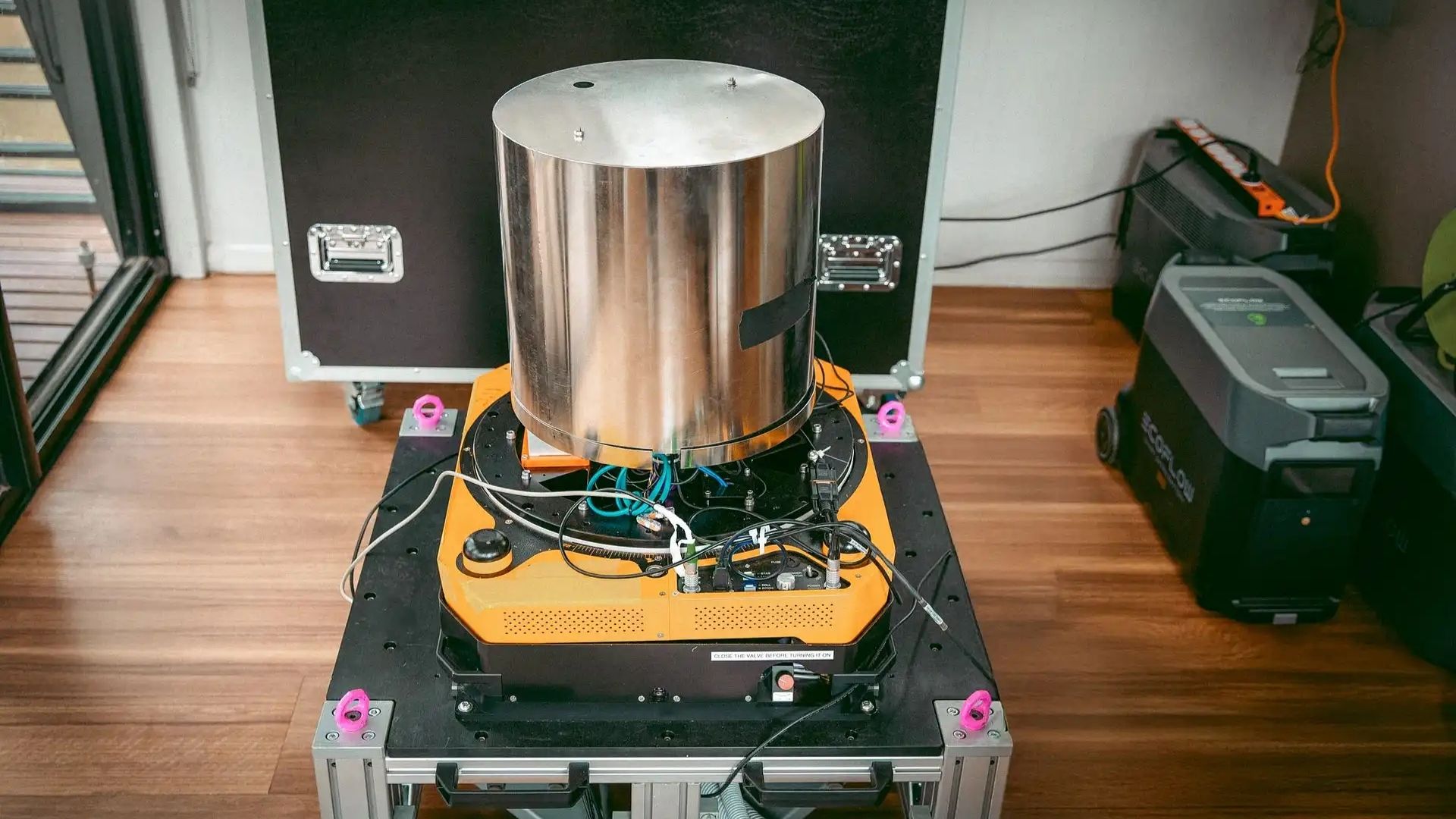
In a milestone for resilient maritime operations, engineers have completed the first successful sea trial of a quantum-based navigation system operating entirely without satellite assistance. As reported on August 28, 2026, by technology reporter Ameya Paleja, the experimental sea trials demonstrated that marine vessels can calculate their geographical position by utilizing ultra-sensitive quantum sensors to read minute variations in the Earth’s gravitational field. The success of the trial marks a shift toward establishing self-contained positioning systems capable of maintaining navigational accuracy when conventional Global Positioning System (GPS) signals are jammed, spoofed, or unavailable.
Key facts
What happened
During the newly reported sea trial, researchers installed specialized quantum gravimetric sensors aboard a marine vessel to evaluate whether cold-atom quantum technology could reliably track position across open ocean conditions. Standard marine navigation relies almost universally on Global Navigation Satellite System (GNSS) signals—including the United States' GPS, Europe's Galileo, Russia's GLONASS, and China's BeiDou—which broadcast radio frequency timing data from medium Earth orbit.
In contrast, the system tested in the trial operates onboard without receiving external electromagnetic signals. According to reporting by Ameya Paleja, the trial utilized quantum sensors capable of measuring minuscule changes in local gravitational acceleration caused by underwater topography, varied crustal density, and sub-surface geological structures.
As the ship navigated its route, the quantum sensors continuously recorded gravitational gradient measurements. The system’s onboard computer compared these real-time gravimetric signatures against known baseline maps of the Earth’s gravitational field—a technique known as gravity anomaly matching or gravimetric navigation. By pinpointing unique gravitational peaks and troughs along the ocean floor, the quantum system established the vessel's latitude and longitude without relying on satellite downlinks or radio emissions.
The trial demonstrated that quantum gravimeters, historically restricted to static laboratory environments due to their extreme sensitivity to motion and wave vibration, can be stabilized sufficiently to deliver usable positioning data on a moving vessel at sea. This achievement validates years of experimental research into field-deployable atom interferometers designed to withstand the motion of maritime deployment.
Why it matters
The success of satellite-free quantum navigation carries far-reaching consequences for global defense, maritime logistics, and critical infrastructure security. Commercial shipping fleets move approximately 80 percent of global trade by volume, making the marine sector intensely reliant on continuous, accurate position data. Modern satellite navigation systems, however, are increasingly vulnerable to deliberate electronic disruption. Electronic warfare tactics such as signal jamming and location spoofing—where fake GPS signals are broadcast to mislead ship captains—have become widespread in geopolitical flashpoints, including the Black Sea, the Baltic Sea, and the Strait of Hormuz.
Beyond military jamming, satellite navigation architectures face systemic vulnerabilities from space weather events. Severe coronal mass ejections from the sun can disable satellite electronics or distort the Earth's ionosphere, rendering civilian GPS receivers inaccurate or completely non-functional across entire hemispheres for hours or days at a time.
Quantum gravity navigation provides a totally passive, un-jammable alternative. Because the system measures intrinsic physical properties of the Earth itself, external adversaries cannot block, fake, or interfere with its measurements. For naval surface ships and submarines, this capability allows extended operations in hostile or signal-denied environments without risking location exposure through active radio emissions. Submarines, which cannot receive high-frequency GPS signals while submerged without deploying surface antennas, stand to gain continuous high-accuracy positioning during prolonged deep-water deployments. Furthermore, autonomous cargo vessels and uncrewed underwater vehicles could rely on quantum gravimetry to execute long-range ocean transits securely.
The background
Global satellite navigation originated in the mid-20th century, culminating in the deployment of the U.S. Department of Defense's NAVSTAR GPS constellation, which achieved full operational capability in 1995. While GPS transformed civilian aviation, maritime transit, and telecommunications synchronization, its core vulnerability lies in signal strength. Satellite signals travel over 20,000 kilometers to reach Earth, arriving at receivers with extraordinary weakness—comparable to viewing a low-wattage lightbulb from thousands of miles away. Consequently, low-power terrestrial transmitters can easily overpower satellite signals across vast geographic zones.
To address GPS reliance, military and research organizations have historically turned to Inertial Navigation Systems, which use mechanical or optical gyroscopes and accelerometers to calculate position relative to a known starting point through dead reckoning. However, conventional inertial systems suffer from exponential drift, accumulating location errors over time that require periodic GPS resets to maintain precision.
Quantum sensing offers a solution to sensor drift through atom interferometry. In a typical quantum accelerometer or gravimeter, lasers trap and cool gas clouds—often composed of rubidium or cesium atoms—to near absolute zero, forming an ultra-cold atomic cloud. Lasers are then used to manipulate the wave-like quantum properties of these cold atoms, measuring how they free-fall under the influence of gravity. Because atomic fundamental constants do not change or degrade over time, quantum sensors eliminate the physical drift inherent in mechanical components.
Research initiatives across the United States, the United Kingdom, France, and Australia have spent the past decade attempting to miniaturize these quantum devices and ruggedize them against external vibration. Organizations such as the U.S. Defense Advanced Research Projects Agency (DARPA) and the UK's Defence Science and Technology Laboratory, along with academic institutions such as Imperial College London, have led trials demonstrating quantum accelerometers in laboratory and flight settings. The successful application of quantum gravimetry aboard a vessel at sea represents the culmination of these multi-decade engineering efforts to transition quantum physics from controlled research labs to operational field units.
Reaction
While specific statements from international defense ministries were not detailed in initial reports, maritime security analysts and naval defense experts have long identified quantum navigation as a transformative technology for naval warfare and commercial safety.
Military commanders and maritime security strategists are expected to closely monitor the trial's performance metrics as governments seek to build resilient navigation architectures resilient against electronic warfare. Naval procurement agencies in major maritime nations are expected to request formal evaluations of the system's operational readiness, focusing on how quickly the technology can be integrated into existing bridge management systems and combat management systems.
Industry groups representing commercial shipping operators, such as the International Chamber of Shipping, are anticipated to welcome the development as a potential defense against rising piracy and electronic spoofing incidents in contested international sea lanes. Meanwhile, quantum technology firms and defense contractors are likely to accelerate investment into commercializing portable cold-atom sensors, competing to establish standardized protocols for gravimetric data integration.
What we don't know yet
Despite the successful demonstration, several key technical and operational parameters remain undisclosed in the reporting by Ameya Paleja. First, the exact positional accuracy achieved by the quantum system during the sea trial—and how its margin of error compares to high-precision satellite differential GPS—has not been specified.
Second, the operational resolution and availability of global gravitational maps pose a major question mark. Gravimetric navigation requires ultra-high-resolution baseline maps of ocean-floor gravitational anomalies. While major offshore zones and strategic waterways have been mapped by bathymetric and satellite gravimetry missions, vast swathes of the deep ocean remain mapped only at low resolutions, potentially limiting the system's effectiveness in uncharted waters.
Third, the physical dimensions, power requirements, and manufacturing costs of the trial hardware are unknown. Current cold-atom quantum sensors often require complex laser systems, high-vacuum chambers, and substantial power supplies. Whether these systems can be miniaturized into cost-effective packages suitable for smaller commercial vessels or autonomous drones remains a critical open question.
What to watch
In the coming months, industry observers should track several key milestones to gauge the commercial and operational trajectory of quantum sea navigation:
This report is based on initial news coverage published on August 28, 2026, by technology journalist Ameya Paleja.
How this story was produced
This report was written by The Global Wire newsroom from reporting first published by Ameya Paleja. We verify the core facts against the original report, write our own account, and add the background and consequences a short wire item leaves out. Drafting is AI-assisted inside an editor-supervised pipeline, and every story is checked for accuracy of attribution, structure and duplication before it appears — full detail in our AI and funding disclosure.
Spotted an error? Tell us at corrections@horizonglobalnews.com and read our corrections policy or editorial standards.


Reader comments
Loading comments…