

Wildfires in Indonesia Sweep Toward Sulawesi Caves Housing World’s Oldest Art
Seasonal blazes that have devastated Sumatra and Borneo spread east to Sulawesi, endangering fragile limestone caverns containing prehistoric art up to 67,000 years old.
By The Global Wire Newsroom · Reported from Reuters
Link preview · horizonglobalnews.com
Wildfires in Indonesia Sweep Toward Sulawesi Caves Housing World’s Oldest Art
Seasonal blazes that have devastated Sumatra and Borneo spread east to Sulawesi, endangering fragile limestone caverns containing prehistoric art up to 67,000 years old.
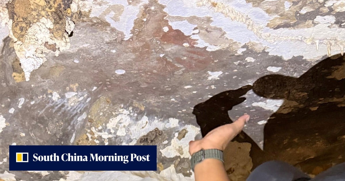
Wildfires burning across Indonesia have reached the island of Sulawesi, placing some of the world's oldest known figurative cave paintings in immediate danger as smoke, radiant heat, and airborne soot encroach on remote limestone formations. While the primary concentrations of this year's seasonal fire crisis have centered on the heavily deforested peatlands of Sumatra and Kalimantan on the island of Borneo, satellite monitoring and emergency personnel confirmed that blazes have extended into Sulawesi's rugged interior. The affected karst landscapes shelter prehistoric galleries—some recently dated to as early as 67,000 years ago—that document the earliest known creative expressions and narrative storytelling in human history.
Key facts
What happened
Seasonal agricultural fires and uncontrolled blazes, exacerbated by protracted dry conditions, escalated across the Indonesian archipelago through late October. While forest and land fires are an annual occurrence across Southeast Asia, particularly during clearing seasons for palm oil and pulpwood timber plantations, fire fronts this season pushed deeper into atypical terrain across eastern Indonesia. According to reporting by Reuters, while Sumatra and Borneo have sustained the most severe environmental destruction and toxic haze levels, fire lines have also ignited in parts of Sulawesi.
Sulawesi's limestone karst towers, which rise abruptly from lowland agricultural plains and dense coastal scrub, are honeycombed with hundreds of natural caverns. These caves contain ochre-pigmented depictions of native wildlife—including the babirusa pig-deer and miniature water buffalo known as anoa—alongside human-animal hybrid therianthropes and negative hand stencils. Field reports indicate that uncontrolled ground fires burning through dry underbrush and secondary forest around the bases of these karst towers are exposing cave entrances to thick plumes of particulate-laden smoke, ash fall, and extreme shifts in cavern microclimates.
Fire suppression across the archipelago remains hampered by geographic dispersal. Indonesia’s national disaster management agency and regional fire brigades have committed the bulk of their airborne water-bombing helicopters and ground crews to the vast peat basins of South Sumatra, Riau, Central Kalimantan, and West Kalimantan. Peat fires in those western provinces generate transboundary haze that triggers regional diplomatic pressure from neighboring Singapore and Malaysia. In contrast, the remote karst areas of Sulawesi feature complex vertical terrain that restricts heavy vehicle access, leaving local forestry rangers, community volunteers, and provincial conservation officials to battle encroaching flames with portable water pumps, manual firebreaks, and limited logistical support.
Why it matters
For archaeology and human evolutionary anthropology, the threat to Sulawesi’s cave system risks the permanent erasure of primary historical evidence regarding when and where modern humans developed complex symbolic thought. For much of the twentieth century, academic consensus situated the emergence of narrative art, representational painting, and religious imagination in the Ice Age caverns of Western Europe, such as Chauvet, Lascaux, and Altamira in France and Spain, which date to roughly 30,000 to 40,000 years ago. Discoveries in Sulawesi over the past two decades systematically overturned that Eurocentric paradigm, proving that hunter-gatherer populations in Island Southeast Asia were producing sophisticated figurative art and narrative scenes tens of thousands of years earlier.
Limestone art is exceptionally fragile. The ochre pigments—composed primarily of iron oxides mixed with water or organic binders—sit on thin outer skins of calcium carbonate. When wildfires burn adjacent to cave mouths, they generate three distinct forms of irreversible physical damage. First, the deposit of greasy carbon soot covers the microscopic crevices of the rock, obscuring pigmentation and contaminating the surfaces, which renders future radiometric and uranium-series dating impossible. Second, rapid increases in temperature cause differential thermal expansion between the limestone host rock and outer mineral crusts, triggering spalling, where the surface layers crack and drop off the walls. Third, the combustion of surrounding biomass permanently alters the internal humidity and airflow of the caves. When relative humidity drops, moisture carrying dissolved salts evaporates rapidly inside the rock wall, crystallizing behind the pigment in a process known as haloclasty that blasts the painted surface away as dust.
Beyond cultural heritage, the spread of fires to Sulawesi underscores the failure of environmental containment strategies across the archipelago. Peat and forest fires in Indonesia release substantial volumes of greenhouse gases into the atmosphere, contributing measurably to global emissions and subjecting millions of residents to PM2.5 concentrations far exceeding World Health Organization safety guidelines. If fires routinely penetrate ecologically and geologically sensitive karst reserves, protected areas previously shielded by natural topography will face regular structural degradation.
The background
Indonesian fire seasons are dictated by monsoonal weather cycles, frequently intensified by positive Indian Ocean Dipole conditions and El Niño weather patterns that delay seasonal rains. To prepare land for planting, smallholders and concession contractors have historically used fire as the cheapest and fastest method to clear vegetation. In 2015 and again in 2019, catastrophic fire events scorched millions of hectares across Indonesia, blanketing Southeast Asia in choking smoke for months and causing billions of dollars in economic and health-related damages. In response, Jakarta instituted regulatory reforms, including moratoria on primary forest clearing, the creation of a dedicated Peatland and Mangrove Restoration Agency, and legal enforcement actions against non-compliant concession holders. However, enforcement remains uneven, especially outside the industrial plantation belts of Sumatra and Kalimantan.
Sulawesi’s archaeological significance emerged on the global stage in 2014, when a joint Indonesian and Australian research team published uranium-series dating of coralloid speleothems—mineral growths known colloquially as "cave popcorn"—overlaying hand stencils in the Maros-Pangkep district of South Sulawesi. The dating established ages of at least 39,900 years, matching the oldest European sites. Subsequent scientific expeditions produced even older milestones: in 2019, researchers identified a 4.5-meter-wide hunting scene in Leang Bulu’ Sipong dated to at least 43,900 years ago; in 2021, an image of a Sulawesi warty pig in Leang Tedongnge was dated to at least 45,500 years ago. More recent dating techniques employing laser-ablation uranium-series micro-profiling in caves such as Leang Karampuang pushed the timeline further back, culminating in discoveries dating human presence and symbolic art back as far as 67,000 years.
Even before this fire outbreak, researchers documented that these paintings were deteriorating at an accelerating pace. A landmark study published in 2021 by Australian and Indonesian conservation specialists found that changing weather patterns, industrial development in surrounding valleys, and dust from cement quarries were accelerating salt crystallization across Maros-Pangkep. The findings warned that without strict microclimate protections, the paintings could disappear within generations. The arrival of uncontrolled wildfires directly at the cave margins dramatically shortens that timeline.
Reaction
While central ministries in Jakarta have not yet issued public briefings specifically detailing damage assessments within the Sulawesi cave systems, international cultural organizations and academic groups are closely tracking the situation. Global bodies such as UNESCO—which maintains parts of South Sulawesi on its tentative list for World Heritage status—customarily coordinate with national heritage bodies during environmental emergencies to determine whether international technical assistance or rapid-response conservation funds can be deployed.
Archaeological institutions that have led research in the region, including the Indonesian National Research and Innovation Agency (BRIN) and partner universities in Australia, are expected to seek access once fire lines are stabilized to assess pigment integrity and speleothem surfaces. Domestically, regional environmental coalitions and cultural preservation networks in South and Central Sulawesi have repeatedly urged provincial authorities to divert localized fire-management funding away from purely agricultural boundaries to construct defensible buffer zones around high-density cave corridors.
What we don't know yet
Essential operational details regarding the proximity and impact of the fires remain unverified. It is not yet clear precisely which cave sites in Sulawesi are threatened, or whether any blazes have directly entered the main cave mouths in the Maros-Pangkep region, the Bone basin, or more easterly karst formations. Because these archaeological sites are distributed across rugged and isolated valleys, ground-level assessment is slow, and emergency monitoring has prioritized active residential threats.
Furthermore, the physical status of the rock art remains unknown. Satellite thermal imaging confirms active thermal anomalies in proximity to known karst zones, but optical sensors cannot determine whether smoke penetration has caused soot buildup inside deeper cave chambers or if exterior heat has triggered catastrophic surface spalling. Comprehensive assessments will require in-person spectroscopic and micro-photographic analysis by specialized conservators once active combustion ceases and air quality within the chambers stabilizes.
What to watch
The immediate variable determining the outcome in Sulawesi is the arrival of the northwest monsoon, which typically begins bringing regular, heavy precipitation across the Indonesian archipelago between late October and November. Any delay in seasonal rainfall will allow ground fires to continue creeping through the dry forest litter surrounding limestone formations.
In the coming weeks, attention will turn to the Indonesian Ministry of Culture and regional preservation offices (Balai Pelestarian Kebudayaan) as they deploy inspection teams to survey the caves. Observers should watch for preliminary field reports documenting whether active smoke intake caused soot blackening on known rock panels, such as those at Leang Bulu' Sipong or Leang Karampuang. On a policy level, the incident is likely to renew pressure on Jakarta to establish formal fire-management perimeters around vulnerable cultural heritage landscapes, incorporating automated thermal monitoring and dedicated water reserves within karst preservation zones.
Reporting by Reuters provided the primary information regarding the spread of Indonesian wildfires into Sulawesi and the consequent threat to the ancient cave paintings.
How this story was produced
This report was written by The Global Wire newsroom from reporting first published by Reuters. We verify the core facts against the original report, write our own account, and add the background and consequences a short wire item leaves out. Drafting is AI-assisted inside an editor-supervised pipeline, and every story is checked for accuracy of attribution, structure and duplication before it appears — full detail in our AI and funding disclosure.
Spotted an error? Tell us at corrections@horizonglobalnews.com and read our corrections policy or editorial standards.





Reader comments
Loading comments…