

Nepal's Trishuli River Floods Destroy Homes and Markets Following Tibetan Runoff
Severe flash flooding along the Trishuli River in central Nepal, triggered by heavy rainfall in Tibet Autonomous Region, has swept away markets, homes, and transit infrastructure.
By The Global Wire Newsroom · Reported from India Today Video Desk
Link preview · horizonglobalnews.com
Nepal's Trishuli River Floods Destroy Homes and Markets Following Tibetan Runoff
Severe flash flooding along the Trishuli River in central Nepal, triggered by heavy rainfall in Tibet Autonomous Region, has swept away markets, homes, and transit infrastructure.
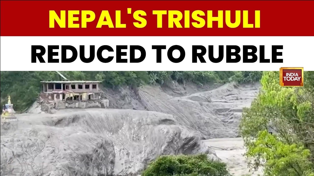
A catastrophic surge of flash flooding along the Trishuli River in central Nepal has caused severe destruction, tearing through towns, eroding riverbanks, and obliterating vital civic infrastructure. According to field reporting by India Today published on August 27, 2026, the sudden inundation was driven by severe torrential rainfall and transboundary water overflow originating across the northern border in Tibet. The swift rise in water volume altered the river’s established channel, creating a raging deluge that swept away residential neighborhoods, commercial market districts, an educational institution, and a central transit hub. The disaster highlights the acute vulnerabilities of mountain communities situated downstream from high-altitude Himalayan catchments, where extreme monsoonal weather and cross-border river surges can rapidly transform local hydrogeology with minimal advance warning.
Key facts
What happened
The inundation unfolded rapidly following an intense precipitation event and severe water overflow in upper Tibetan catchments, which feed into the transboundary river system flowing southward into Nepal. As excessive volumes of water surged down the steep Himalayan gradient, the Trishuli River experienced a swift rise in its stage level, overwhelming natural channel capacities and embankments.
According to ground reporting by India Today, the massive force of the oncoming floodwaters physically altered the natural path of the river bed. As the main flow carved a new alignment through the river valley, high-velocity currents undercut unstable riverbanks and hillsides, directing the main channel straight into built-up human settlements.
The altered river current struck multiple populated centers along the valley floor. In commercial zones, entire market rows were flooded and dismantled, destroying small shops, stored goods, and physical structures. Residential areas situated near the banks suffered massive structural failures; family homes were swept off their foundations or crushed beneath the combination of turbulent water, mud, and heavy sediment.
In addition to private residences and retail centers, public infrastructure sustained catastrophic damage. Ground observations confirmed that a local educational facility was completely destroyed after being caught in the direct line of the diverted river. A municipal bus stand, which served as a critical regional transit node, was similarly submerged and dismantled by the raging torrent. When the immediate peak flow subsided, affected areas were left buried under dense layers of mud, sand, and river debris, leaving transport routes impassable and community spaces reduced to ruins.
Why it matters
The destruction of infrastructure along the Trishuli River valley carries severe consequences for the local population, regional commerce, and national infrastructure networks in Nepal. Beyond the loss of shelter and personal assets, the collapse of commercial market places strips dozens of families of their livelihoods. In rural Himalayan valleys, small market hubs serve as vital distribution points for food, medicine, and daily necessities; their destruction creates severe supply disruptions for surrounding villages.
The loss of a school building represents a major blow to public social infrastructure, displacing students and disrupting education in a region where alternative facilities are often hours away across difficult terrain. Meanwhile, the destruction of transit nodes such as the municipal bus stand severely hinders local mobility, emergency medical evacuations, and relief delivery, isolating rural communities.
From an economic perspective, the Trishuli River basin is one of Nepal's most vital infrastructure corridors. The valley hosts several major run-of-river hydroelectric power facilities, including the Trishuli Hydropower Station, Devighat, and Upper Trishuli 3A, which contribute substantially to Nepal's domestic power grid. Severe floods carrying high concentrations of sediment and debris pose significant risks to turbine machinery, intake structures, and transmission lines. Power disruptions in this corridor can lead to broader electricity shortages across central Nepal, including the Kathmandu Valley.
Furthermore, the corridor serves as a primary trade highway linking Kathmandu to the Rasuwagadhi border crossing with China. Disruption to transport infrastructure along this route impacts cross-border trade, delaying cargo shipments and driving up transport costs.
The background
The Trishuli River—known in its upper reaches in Tibet as the Kyirong Tsangpo or Bhote Koshi—originates on the high-altitude Tibetan Plateau north of the Central Himalayas. It flows southward, cutting deep, steep gorges through the Himalayan range into Nepal's Rasuwa and Nuwakot districts before joining the wider Gandaki River basin. Because of the river's high drop in elevation over a short distance, it possesses immense water velocity, making its banks highly vulnerable to rapid lateral erosion when river discharges spike.
Nepal's climate is dominated by the South Asian summer monsoon, which typically extends from June through September, delivering approximately 80 percent of the country's annual precipitation. In recent decades, hydro-meterological studies in the Himalayan region have documented an increasing frequency of localized cloudbursts alongside accelerating glacial retreat and altered weather dynamics across the Tibetan Plateau.
Transboundary flood hazards represent a chronic structural vulnerability for Nepal. Because many of Nepal's major river systems have headwaters located inside the Tibet Autonomous Region of China, downstream Nepalese communities are direct recipients of hydrological events originating outside their national borders. Past disasters, such as the catastrophic Bhote Koshi flash floods in 2016 and the 2021 Melamchi River flood, demonstrated how cross-border torrential rainfall, landslide-dam outburst floods, or glacial lake outburst floods can rapidly send devastating surge waves into Nepal's river valleys.
Managing these risks relies heavily on early warning systems and bilateral data-sharing mechanisms between Nepal and China. Nepal's Department of Hydrology and Meteorology (DHM) and the National Disaster Risk Reduction and Management Authority (NDRRMA) operate river gauging stations, but extreme high-altitude events upstream in remote Tibetan terrain frequently elude real-time detection unless robust cross-border telemetry is fully operational.
Reaction
Following major flood events along Himalayan river channels, emergency response protocols in Nepal typically trigger immediate intervention by local and national disaster management authorities. While the initial field report from India Today did not include formal government statements, standard operating procedure in Nepal calls for the deployment of search and rescue units from the Nepal Army, the Armed Police Force, and the Nepal Police under the direction of local District Disaster Management Committees.
Local government officials in affected districts are expected to coordinate emergency shelter options for displaced residents, using temporary facilities such as community centers or surviving public buildings. Humanitarian organizations, including the Nepal Red Cross Society and local civil society groups, typically step in to provide emergency food rations, clean drinking water, tarpaulins, and hygiene kits.
Engineers from Nepal's Department of Roads and the Nepal Electricity Authority are customarily dispatched following river surges to assess structural damage to bridges, highway retaining walls, and power generation units. Additionally, disaster management experts in Nepal frequently reiterate the need for political authorities in Kathmandu and Beijing to strengthen real-time hydrometeorological data exchanges to ensure downstream settlements receive sufficient lead time to evacuate.
What we don't know yet
Despite the visual confirmation of widespread destruction provided by the ground report, several critical details regarding the full scope of the disaster remain unverified:
What to watch
In the coming days and weeks, key developments will determine the recovery trajectory and regional impact of the Trishuli flood disaster:
This report is based on original field reporting provided by the India Today Video Desk.
How this story was produced
This report was written by The Global Wire newsroom from reporting first published by India Today Video Desk. We verify the core facts against the original report, write our own account, and add the background and consequences a short wire item leaves out. Drafting is AI-assisted inside an editor-supervised pipeline, and every story is checked for accuracy of attribution, structure and duplication before it appears — full detail in our AI and funding disclosure.
Spotted an error? Tell us at corrections@horizonglobalnews.com and read our corrections policy or editorial standards.





Reader comments
Loading comments…